
A blizzard warning remains in effect for parts of Connecticut along the shoreline -- New Haven, Middlesex and New London counties -- until 1 a.m. Friday and some schools have made the decision to close for another day on Friday.
Blizzard conditions mean travel will be very dangerous, extremely high winds are likely, and whiteout conditions are possible. Snowfall rates reached around a foot for some parts of the state on Thursday.
Hundreds of school districts and several businesses were closed on Thursday. Some school districts announced they will be closed on Friday, as well.
The highest snowfall totals from this system was along the Interstate 395 corridor in eastern Connecticut.
Ahead of the storm, the governor activated the state's Emergency Operations Center, which went into effect at 6 a.m. to monitor the storm and non-essential state employees were told to stay home Thursday.
The Department of Transportation has had 634 state trucks and another 200 private contractors ready to respond to this storm. There are also 17 industrial snowblowers prepared to help with the clearing efforts.
Transportation:
CT Transit suspended express bus service because of worsening conditions. The last express buses from Hartford left at 12:20 p.m., the last express bus from Waterbury to Hartford left at 12:10 p.m. and the last express bus from Storrs to Hartford left at 1:46 p.m. Express service was suspended for the rest of Thursday.
CTfastrak and CTTransit local bus service continued to operate with snow detours in effect.
Local

Bradley International Airport had several cancelations and reported that 90 percent of flights had been canceled. An airport spokesperson said the airport expects flight operations to resume on Friday, however, airlines continue to adjust their schedules and catch-up in response to the story, so passengers should expect delays and cancelations. Passengers are urged to contact airlines before their flight on Friday.
Cross Sound Ferry has also canceled several ferry departures on Thursday.
Peter Pan bus line has canceled all routes north of New York City for Friday.
State Offices:
The governor on Wednesday directed all non-essential first- and second-shift state employees not to report to work on Thursday but said third-shift employees should come for their usual schedule. He expects all government buildings to be open on Friday for normal work hours.
DMV: The DMV has canceled all road skills tests for Thursday and until noon on Friday.
Jury Duty: The state judicial branch canceled jury duty for Thursday because of the storm.
IMPACTS:
Snowfall Accumulation
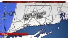
We're forecasting 8 to 15 inches throughout the entire state.
Timing
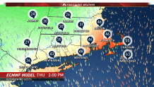
Snow began to overspread the state during the early morning hours on Thursday and lingering snow showers and flurries that stopped in the evening.
Wind
The strong winds will continue into Friday. Wind gusts over 40 mph are possible, especially in coastal areas of southeastern Connecticut.
This could lead to sporadic power issues throughout the state. Check Eversource power outages here. Check United Illuminating outages here.
Cold
Some extreme cold will follow the storm for Friday and Saturday. This could be concerning if there are power outages throughout the state. Cracked water pipes are one of the issues we are concerned about.
High temperatures on Friday are only expected to reach 10 degrees for inland areas. Some cities and towns won't even make it out of the single digits.
Even colder air will arrive by Saturday with morning low temperatures between -5 and -15 in parts of the state with afternoon high temperatures between 5 and 10 degrees.
