
What to Know
- WHAT: A mixture of snow, sleet, and rain will move in late Christmas Eve.
- WHEN: Starting between 10 p.m. and 1 a.m. Christmas Eve and ending between 7 a.m and 10 a.m. Christmas Day.
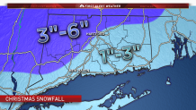
- WHERE: All of Connecticut with highest accumulations in northwest and north central Connecticut. Mixing expected along the I-95 corridor.
After a wintry mix tonight into tomorrow NBC Connecticut Meteorologists are forecasting snow, sleet, and rain Christmas Eve into Christmas day.
Much of Christmas Eve will remain dry with high temperatures in the upper 30s and low 40s.
We're forecasting a mixture of snow, sleet, and rain to overspread the state between the hours of 10 p.m. Sunday and 1 a.m. Monday.
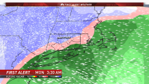
Areas along the shoreline will be dealing with rain to start with a transition to sleet and snow during the overnight hours.
Parts of interior Connecticut especially from Litchfield county to Tolland county will be dealing with plowable snow by Christmas morning.
Take a look at snowfall accumulations. Higher accumulations will in northwest and north central Connecticut where precipitations should stay primarily snow.
The snow, sleet, and rain will come to an end by 7 to 10 a.m.
Local

Stay with the NBC Connecticut First Alert Weather Team for the very latest on the situation.
