
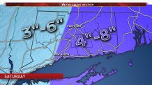
Winter storm warnings have been issued for parts of Connecticut ahead of our first winter storm of the season. I've nudged up snow totals a bit tonight to account for the potential of 7" or 8" of snow in parts of eastern Connecticut. That said, most towns will see around 5" of snow.
Tonight, we're dry. You can see on the evening weather balloon launch from Long Island a pocket of very dry air in the lowest 10,000 feet of the atmosphere. No snow is going to make it through that!
Eventually, however, the snow will come. The offshore moisture will surge back northwest and that dry layer will quickly moisten up. We're quite confident in where the storm will track. Now that the general setup is clear we need to lock in the snow forecast - and this is a quick and dirty look at how I do it.
Not much has changed since yesterday with the storm other than a slight uptick in the amount of forecast precipitation. The GFS shows between 0.3" to 0.6" of liquid across the state while the NAM and Euro shows between 0.4" and 0.7" of liquid. These numbers seem reasonable to me given the storm's movement and intensity.


Now that we're reasonably certain how much liquid water will fall from the clouds we need to figure out the ratio of snow to liquid water. Not all snow flakes accumulate at the same rate! Some snowflakes accumulate readily while others are dense and accumulate slowly. In fact, even without melting, snow:liquid ratios can range from 6:1 to 40:1! Life would be much easier if I could just forecast how much liquid water would fall!
Most snowstorms in Connecticut manage around 10" of snow to 1" of water, or 10:1 as we call it, and I'm expecting this one to be close to that.
Local


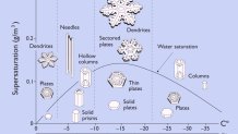
My rule of them is take your forecast liquid and always go 10:1 unless you have convincing evidence to go higher (there are times where I'll to 15:1 or 20:1). The reason we're expecting an "average" ratio is that the ice crystals in the clouds will be growing at temperatures warmer than -12C. This isn't ideal for heavy snow.
Ice crystals growing around -10C or -8C will give us snow crystals like plates and columns. If you wear black gloves outside and catch some snowflakes you'll be able to see them! When snowflakes grow around -15c they grow as dendrites (the beautiful and ornate crystals) and those dendrites grow efficiently and accumulate readily! This snow crystal morphology diagram shows which crystals grow at which temperatures. I'll leave vapor pressure out of this lesson for now.
The snow begins Saturday morning (around daybreak at the shoreline) and continues through the afternoon and evening. While the intensity will never be particularly strong there will be bands of snow that last off and on through the night. In fact, I wouldn't be surprised to see a bit of fluffy snow early Sunday morning as an upper level disturbance swings through and temperatures drop.
Enjoy the snow!
