
Hurricane Florence has my attention. The hurricane is chugging westward and almost all of our available computer guidance shows an awfully ominous scenario about one week from now.
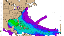
At first glance, Florence is not in a location that's favorable for a United States landfall. Based solely on climatology (previous hurricanes) the odds of a hurricane in Florence's current location coming close to the east coast are extremely low. This graphic from Bob Hart at Florida State shows how far north and east Florence is compared to where U.S. hurricanes typically track. Less than one percent of storms in this location go on to make landfall in the U.S. (in fact if we dig deeper we can't find any storm in history that has come close).
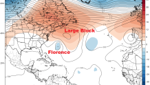
What's interesting, however, is that the weather pattern over the North Atlantic is not normal. A highly unusual and anomalous ridge of high pressure is expected to develop from New England through the Canadian Maritimes and North Atlantic next week. This effectively acts as a block for Florence preventing the hurricane from curving out to sea like we typically see storms in this position do.
While the current position of Florence is highly unusual for a U.S. hurricane threat the developing weather pattern is concerning. It is also highly unusual. Highly anomalous weather patterns can produce highly anomalous results.
Local

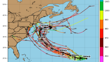
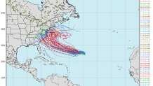
So what happens? Our computer models today show a number of different scenarios which is what you'd expect to see for a day seven or day eight hurricane forecast. What's remarkable, however, is how many solutions are awfully close to the east coast. The spaghetti plots below (each "strand of spaghetti" indicates a different computer model solution from either the GFS or European ensemble) show potential tracks of Florence. There are quite a few that show at least some impact from the Carolinas through New England.
Here's what you need to know:
- At this point some impact from Florence is possible from the Carolinas through New England but what kind of impact is unclear.
- *IF* we saw something it would likely be Thursday or Friday of next week.
- There's nothing to worry about right now - but by the weekend that may change.
- Most importantly, Florence is a good reminder that you should be prepared for any kind of weather emergency particularly if you live along the shoreline and are in or near an evacuation zone.
- A direct hit in Connecticut from Hurricane Florence remains exceptionally unlikely. That said, it's something we can't rule out entirely.
- For now, let me worry about Florence. When it's time we will of course be the first to let you know that you should worry too.
