
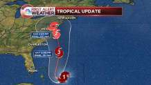
Hurricane Joaquin has strengthened east of the Bahamas, upgraded to a category 3 hurricane, and it is likely to make landfall in the Mid-Atlantic, somewhere between the Carolinas and New Jersey early next week.
While the storm is forecast to make landfall in the United States, it's important to communicate all possibilities. One solution, albeit less likely, is that the storm heads out to sea to the east. The European model has consistently shown the out-to-sea solution. It remains a possibility.

Over the past few days, the track changed considerably. Now, most modelling has come to a consensus that the storm will in fact take a turn north and then west. As of Wednesday evening, most of the models on the "spaghetti" plot take the storm ashore in North Carolina.

The National Hurricane Center expects the storm to continue drifting southwest towards the Bahamas until in turns north on Friday. Once the storm turns north, it will rapidly accelerate. The official track takes the storm into the Chesapeake Bay, which is north of most of the models.
While a direct hit is unlikely in Connecticut, there's a large amount of moisture with Joaquin. This means more rain is likely this weekend into early next week.
Connecticut saw a couple inches of rain on Wednesday, without much issue. Still, if a large amount of rain falls this weekend it could cause flooding issues, especially of the urban and small stream type.

The two less likely scenarios are that Joaquin heads east out to sea or tracks into New England. Still days out, it's appropriate to keep these options on the table despite the fact that the forecast calls for a Mid-Atlantic landfall.
Local


Meteorologists Tyler Jankoski and Ryan Hanrahan answered questions on Facebook this afternoon. Visit the NBC Connecticut Facebook page to read the answers.
Joaquin is now a hurricane and the likelihood that it will make landfall somewhere on the East Coast has increased. ...
Posted by NBC Connecticut on Wednesday, September 30, 2015
The First Alert weather team will have the latest information online and on-air all week long.
