
What a mess out there this evening. Freezing rain across the state (as far south as New Haven) as resulted in a glaze of ice on untreated surfaces across Connecticut. We have reports of accidents in eastern Connecticut and I'm sure countless people have fallen on sidewalks, driveways, and decks tonight!
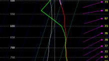
Unfortunately our freezing rain is going to continue into Saturday morning across the interior. Our computer models are almost always too quick to scour out cold dense air wedged in the valleys and this is no expection. The evening NAM computer model which handles these setups the best of our models shows temperatures near 32 degrees as late as early afternoon around Bradley Airport right at the ground.
This is a classic case of cold air stuck in the Connecticut River valley (hills of 1,000 feet on either side) that is reinforced by a gently northerly drain of air from Massachusetts. One other area to watch is New Haven. Cold air can drain easily down the Quinnipiac River and get trapped between Totoket Mountain in North Branford and the Metacomet Ridge (West Rock). I wouldn't be surprised to see freezing rain continuing through early morning around New Haven thanks to the northerly drain.

By Christmas it looks like we may see snow! A late-developing storm on the leading edge of much colder air moving in from the west. Our first cut at snow totals is 3-6" northwest of Hartford and 1-3" southeast of there. There will be a rain/snow line with this storm and there's also some uncertainty how quickly it begins to develop. Our preliminary thinking is a start time between 10 p.m. and 1 a.m. Sunday night/Monday morning and an end time 6 a.m. to 9 a.m. Monday. We'll be watching it closely and update as needed.
