
The 10 day forecast I showed tonight on NBC Connecticut is about as boring as it gets. No big storms, no big cold shots, and just periodic bouts of above to well above normal weather. Zzzzzzzzzzzzzzzzzzzzzzzzzz.
But - beyond the firstw week of December is where things start to get a bit interesting. At the top of the article you can see the December 1-7 temperature forecast from the Climate Prediction Center. There are good odds we will be quite mild! After the 7th, however, our long range computer guidance (Euro ensembles in particular) shows a global jet stream pattern that would really load the dice in favor of snow and coldr. We've got a strong ridge of high pressure over Alaska and up into the North Pole which effectively dumps Arctic air into the northeastern U.S.
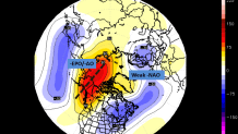
At the same time some remnant -NAO blocking remains over Greenland. This is certainly a look which should excite snow lovers.
Of course all of this assumes the Euro weeklies are correct! Lots can go wrong around and after week 2. The presence of high latitude blocking for several days on our long range models can't be ignored. I think there's a window around 12/10 that will need to be watched closely. Until then.... hibernation after Thanksgiving dinner is not a bad idea.
