
It's about as strong of a signal I've seen for a major winter storm 4 days ahead of time. A powerful nor'easter will develop after emerging from the Gulf of Mexico on Monday. At this point it's fair to say a significant storm is likely and I would be surprised if at least a portion of Connecticut didn't get a foot of snow.
The storm has all the makings of a blockbuster.
- A deep and cold antecedent airmass with a sprawling large high pressure to the north.
- A bit of downstream blocking of the jet stream near Greenland.
- A potent and moisture laden disturbance exiting the Gulf of Mexico with a second disturbance diving south from the Great Lakes. How these interact will be the key to where the storm tracks.
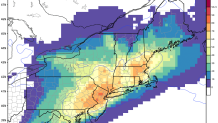
Let's look at our overnight computer guidance for example. The European Ensembles (the European model run 51 different times at slightly lower resolution with a few tweaks) shows a 50-70 percet probability of more than a foot of snow across Connecticut. The odds of 18" of snow are between 5% and 20%. For a 96 hour forecast these are huge probabilities!
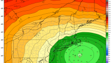
Of course things can change a bit. The key is going to be the storm's strength at our latitude and how close to the coast does it track. Is the storm near Block Island or near Nantucket? If the storm tracks too far west we would introduce sleet and rain issues - if it's too far east the heaviest snow would miss us to the east (i.e. Boston and Cape Cod get clobbered while we get a lesser storm). This map shows all the different locations of the low from those 51 different European Ensemble members.
Here's what we can say right now:
- A major coastal storm/nor'easter is likely on Tuesday and Tuesday night
- The most likely start time is Tuesday morning with the peak of the storm Tuesday afternoon and evening. Let's say 3 p.m.-midnight as a first approximation.
- 1 to 2 feet of snow is a good possibility just northwest of where this storm tracks. Whether that is in eastern New York, eastern Massachusetts, or Connecticut it's too soon to say.
- A jog to the west of the storm that introduces precipitation type issues (sleet and rain) is still a possibility.
- Blizzard conditions and strong or even damaging winds are possible with this storm.
- By later tonight and tomorrow we can start throwing out some preliminary numbers. I have a feeling they'll be big.
