
The track of Hurricane Matthew has changed over the last couple days -- and this is not good news. The latest advisory from the National Hurricane Center (NHC) shows Matthew skirting the coast of Florida and making landfall in the Carolinas. From there Matthew gets awfully close to Southern New England.
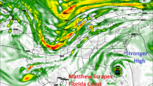
So what's the deal? Why the change toward Florida and North Carolina? The biggest change has been the strength of a large, blocking ridge of high pressure that stretches from Bermuda west toward the Southeastern U.S. This effectively forces Matthew toward Florida and not safely out to sea north of the Bahamas.
This means Florida could see a direct hit from Matthew along with the Carolinas. This could be a pretty nasty storm down there!
The big question for us, however, is what happens to Matthew after it passes the Carolinas. Does it head out to sea or head up the coast? The current track from the NHC brings Matthew awfully close to southern New England by Sunday morning. I think this is a bit too close based on current modeling.
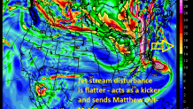
Matthew's future in New England depends on an upper level disturbance in the jet stream that is currently located over western Canada. Does this disturbance dig to the south and capture Matthew or is the disturbance flatter and act as a "kicker" sending the storm out to sea?
This afternoon's GFS (or American) computer model has now joined the "out-to-sea" crowd. The GFS has that disturbance acting as a kicker and sending Matthew east well to the south of Connecticut.
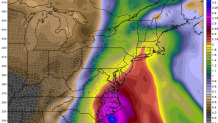
However, the GFS indicates that even though the center of Matthew could be hundreds of miles offshore, we could see a substantial amount of rain as tropical moisture gets drawn north from Matthew and interacts with a cold front over New England. Not much wind, and certainly no storm surge, but the potential is there for drought-busting rains even if Matthew tracks way offshore. You can see on the GFS model even though the center of Hurricane Matthew is near North Carolina moisture is surging north on the precipitable water product (think of this as how much moisture is in the entire atmosphere over a given location).
Another way to look at our computer models is with a spaghetti plot. The GFS model has 21 "ensembles" that are run in addition to the main model. Each of the 21 ensemble members is tweaked slightly to see how much different or similar the solutions are. Tightly clustered "spaghetti" indicates a confident forecast while spaghetti all over the place indicates a very low confidence forecast with multiple possible scenarios. The afternoon GFS ensembles show a more "out-to-sea" solution with some indirect impacts here in Connecticut. The trend on the GFS ensembles today is that a direct hit is very unlikely here.
Here are the final takeaways with Hurricane Matthew...
- A direct hit from a hurricane in Connecticut is very unlikely.
- An indirect hit with rain and damaging wind is still possible IF Matthew tracks close to Cape Cod over the weekend.
- The most likely scenario is a track fairly far offshore which would bring rain (possibly heavy rain with minor flooding) and only minor wind issues.
- There is still a possibility that Matthew could miss Connecticut entirely - passing safely south and east of New England. The European model is now strongly suggesting this.
- The most significant impacts (if any) from Matthew will be later Saturday and Sunday.
- Stay tuned to the forecast! Average forecast errors for a hurricane 5 days away are in the hundreds of miles. Wobbles in either direction (west or east) may have a significant impact on what weather we'll see here in southern New England.
