
A bit of good news for people who need to travel on Thanksgiving. Yesterday, it appeared that we'd have a bit of snow first thing Thanksgiving morning across the state. That chance for snow has evaporated (or sublimated in this case) thanks to a weaker storm and a tenacious bubble of dry air near the ground.
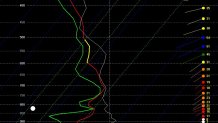
This sounding off the NAM model (previously the most bullish with the snow chance) shows why. There's a decent bit of moisture in the mid levels of the atmosphere (where the green and red lines are close to one another implies humidity near 100%) but in the lowest 5,000 feet of the atmosphere it's a different story. There's a pronounced layer of dry air around 875mb and that will be enough to prevent any snow of consequence.
Still, we're not necessarily out of the woods for all of Thanksgiving. Up in the hills of Litchfield County temperatures will be very close to freezing as a wave of moisture moves in during the late afternoon and early evening.
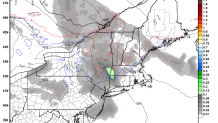
Most of our computer models are on the line between rain and snow/mix above 1,000 feet in the Northwest Hills. The RGEM shows a little burst of precipitation between 4 p.m. and 7 p.m. in the hills and temperatures awfully close to freezing (the blue line is 35F). This is pretty similar to most of our computer models. Farther north, in the Berkshires and southern Green Mountains, an inch or two of snow is likely to accumulate.
The bottom line is that most of the state isn't going to see much at all. A bit of rain in the afternoon and evening. In a few of the hilltowns we're very close to seeing a brief period of wintry mix so we'll be watching that closely.
