
Nothing about this forecast is easy. The nor'easter that forms off the coast is a classic. It has just about all the ingredients needed for a beast of a storm with one exception. That missing ingredient is - cold air!
Temperatures Thursday will climb through the 50s across the state. To the north over Canada there's no good source of cold air. What would ordinarily be an "easy" forecast of 1-2 feet of snow is suddenly quite challenging. How quickly will temperatures cool and how quickly will the rain change to snow.
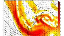
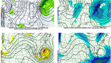
An upper level low will close off just south of New England on Friday. As it does the storm will essentially stall, Do a small loop-de-loop, and then push offshore. It's that "loop" that makes this storm so intriguing and is a hallmark of most of our biggies. The intensity of the storm as it matures just off the coast is also remarkable. Winds about a mile off the ground are progged to approach 100 mph over parts of southern New England.
So, the main pieces are on the table. Heavy rain and strong winds (gusting up to 60 mph) are quite likely. The storm reaches its peak intensity around midday Friday and we will be on the northwest side of both the surface and mid level lows (think of 0ft-10,000ft above our heads) and this is critical. As air rises quickly the atmosphere cools to the northwest of these lows. Additionally heavy melting snowflakes will cool the column as energy is expended to melt the snow into a rain drop. Both processes will be in play on Friday and it appears we will cool enough for a thump of snow - especially in the hills.
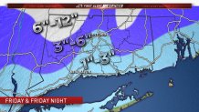
I do know that our snow forecast is higher than any of the other local outlets by a good amount and is substantially higher than the National Weather Service. I could certainly be wrong here! But, this kind of storm looks to me like it will be so intense even in a borderline situation we will likely flip to snow. In the hills a few hundred feet of elevation will go a long way and there may be substantial snowfall differences between hills and valleys. The CIPS analog guidance has the April fools day blizzard of 1997 as its number one analog for this storm which is certainly saying something!
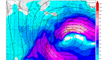
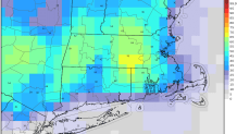
For our snow forecast we discounted the GFS low level temperatures (it is frequently way too warm in these setups and is basically unusable) and we've blended the thermal profiles from the NAM and European models. Additionally, our snow forecast matches closely with the European ensembles - below is the probability of 6"+ of snowfall and you can see greater than 50% odds where we have our 6"+ contour in the Northwest Hills.
Other issues we will have to deal with are damaging winds (especially with heavy, wet snow accumulating on trees and power lines) and coastal flooding. We are quite confident in 40-60 mph wind gusts across the state. As for coastal flooding it appears we may get lucky with a more northerly component to the wind. This essentially directs the wave action away from the shoreline and limits issues. I do see anticipate widespread minor to locally moderate coastal flooding given the combination of storm surge and astronomically high tide.
The threat for coastal flooding - and potentially major coastal flooding - is much higher around Boston where the wind will be more onshore.
Stay tuned for updates - I'm sure there will be many!
