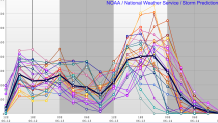
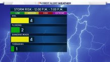
The ingredients are in place for powerful thunderstorms in some towns tomorrow afternoon. An abundance of instability will fuel storms after 1 p.m. and the potential is there for severe thunderstorms as well.

One of the questions we have is how widespread will the storms be. The "forcing" in the atmosphere isn't overly strong and so it's unclear how many storms will be able to tap in to all the instability out there. With CAPE values exceeding 2,000 j/kg due in part to steep mid level lapse rates (rapid temperature drop with height 10-20,000 feet above our head) some storms may really take off.
Instability is just one piece of the puzzle. What will prevent this from becoming a more significant severe weather event is the lack of wind shear. Wind shear, or winds changing speed and direction with height, is critical for storms to organize. While supercells or powerful well-organized storm clusters are unlikely I expect we'll see a number of strong "pulse" storms that strengthen and weaken quickly. Localized downbursts and hail is possible along with an unusually large amount of lightning and very heavy rain.

One thing to note is that with the unusually steep lapse rates and a northwest flow (offshore wind) the storms will be able to make it all the way to the beaches. This is one of those rare setups that favors Stonington Borough just as much as a town in Litchfield County.
Be prepared for some nasty storms tomorrow. We'll have you covered all day on-air and online!

