
What's good news for Connecticut isn't such good news for Florida. Hurricane Matthew's forecast track is becoming much more clear today and we've had to make some large adjustments to the forecast.

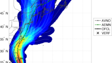
We are now able to sound the all clear for this weekend with respect to Matthew locally. While some showers or a period of rain is possible later Saturday no major impacts are expected. The storm will remain well south of Connecticut. For a few days our computer models hinted that this was a possibility but this solution was in the minority. Take, for instance, the GFS Ensembles. This is the GFS (American) computer model run 21 different times with different tweaks and perturbations to provide a spread of possible solutions. This solution from Friday night shows quite a significant threat to Connecticut with Matthew getting picked up the coast with none of the 21 showing the storm remaining south of North Carolina. These solutions will be wrong.
So what happened? There are a couple things that changed with the forecast. For one, a ridge of high pressure over the Atlantic Ocean is a bit stronger which is forcing Matthew farther west toward Florida (and also slowing the storm down some). The second is that a disturbance in the jet stream that was over the Pacific Ocean is coming in flatter and not as robust - which will effectively miss Matthew.

Had that disturbance been much stronger and dug farther south (as had been previously shown by the GFS) it would have been able to pick Matthew up and send it north toward New England.
Local

Now that it appears Matthew will miss its kick up the coast and even a kick out to sea from the jet stream what the heck will it do? It appears that the storm will stall or even complete an odd (but certainly not unheard of) loop-de-loop off of Florida. Some interaction with Tropical Storm Nicole may aid in this looping track due to something known as the Fujiwhara Effect. Basically, when two cyclones get close to each other they can do some funky things (ideally, two cyclones of the same size and strength will start orbiting in a cyclonic motion around one another).
Attraction and then repellent aversion: dating scene in the tropical Atlantic with Hurricane Matthew and Nicole this weekend. pic.twitter.com/ivK7zmn0BK
— Ryan Maue (@RyanMaue) October 5, 2016
You can see the odd evolution here on the GFS ensemble spaghetti plot. A graze of Florida and then a loop off of Florida and South Carolina. The biggest question still to be answered is just how close Matthew will get to Florida - 30 miles offshore is a much better outcome for the Sunshine State than a direct landfall. It's too soon to say for sure.

Here's the bottom line on Hurricane Matthew...
- No direct impact to Connecticut is expected this weekend.
- A direct hurricane landfall in Florida is possible as is a scrape along the east coast.
- Dry weather expected here over the next several days with the drought continuing. A few showers or a period of rain is possible late Saturday or Saturday night.
