
Gusty winds will usher in colder temperatures tonight and by Friday we'll have some snow flakes in the air. There is not much of a storm on our way - it's more of a ripple in the atmosphere that results in enough "lift" to squeeze out a period of snow.
The 51 european ensembles show the best odds of more than 1" of snow in southeastern Connecticut with lower odds to the northwest of there. This seems pretty reasonable.

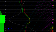
We're not going to pick up much from this storm but there will be a bit of a fluff factor. What do I mean by that? Essentially most of the lift in the atmosphere will occur in the clouds where the temperature is near -15C which is the temperature at which dendrites - those beautiful ornate snow flakes that can pile up quickly - are able to form. Additionally, this is the temperature at which snow flakes form most efficiently. This model sounding off the NAM in Groton shows modest lift centered right near this magic temperature Friday morningh.
Getting lift in the "dendritic growth zone" as we like to call it can result in snow:liquid ratios that exceed the typical 10:1. For example, normally around here we get about 10" of snow for every 1" of liquid. When dendrites are the preferred ice crystal they grow quite rapidly and efficiently and also pile up quickly when they land on the ground. It's not unusual to squeeze out 20 or 30 inches of snow per 1 inch of water if you're looking at all or mainly dendrites. So while we'll struggle to get a tenth of an inch of liquid - getting 1-2" of snow would be a possibility in some areas.
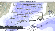
So expect a few fluffy flakes Friday morning during the commute with a bit of accumulation. A coating to a half inch or so around Hartford seems reasonable with a few pockets of up to 2 inches near the shoreline.
