
For the last few days we have been discussing the track of the storm and how it relates to what we see here in Connecticut.
The confidence of the storm track is finally starting to increase.
Latest Storm Track
The latest computer guidance continues to bring warmer and warmer temperatures for Thursday afternoon and evening.
This is resulting in a track that would bring primarily rain to the state.
There is a chance that rain transitions to a wintry mix for areas of Litchfield County.
Let's take a look at the two tracks that are still on the table. Track 2 certainly looks like the most likely solution.


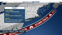
Track 1 (Snowiest Track)
This track would result in rain transitioning to snow or a wintry mix statewide. The highest snowfall accumulations would be see in northern Connecticut.
Track 2 (Wettest Track)
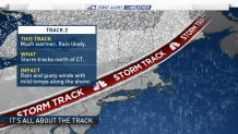
This track would bring the center of the storm right over or north of Connecticut. This would result in rain Thursday night, continuing into early Friday morning..
If you're a snow lover don't be too upset. We're forecasting a abnormally cold air mass for the middle of next week and with that also comes chances for snow.
