
When I woke up around 8 a.m. and checked my phone to see how the storm "performed" at least one or two expletives rolled off my tongue. You can use your imagination. My forecast at 6 p.m. Monday was 0"-1" of snow - and by now we know how that turned out. By 11 p.m. I was mentioning at least 2" in eastern Connecticut but I had an uneasy feeling for sure. Here are a few of the reasons why the storm dropped up to 7" of snow in New London County.
How much dry air?
One of the issues all along with this storm was how much dry air there was above our heads and whether that dry air would stay in place. For nearly 12 hours radar showed precipitation falling over Connecticut on Monday and barely a flake made it to the ground. We call this virga - precipitation that dries up before reaching the ground.
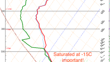
Even at 11 p.m. last night under very heavy bands on radar we were struggling to get even moderate snow to the ground due to the dry air aloft. This sounding from Long Island at 7 p.m. last night shows the pocket of dry air about 7,000 feet up. This was one of the bigger forecast challenges.
As it turned out the atmosphere rapidly saturated south and east of I-84 resulting in heavier snow making it to the ground. Farther northwest in Litchfield County and even in places like Enfield the dry air held firm with only about a coating of snow.
Where's the lift?
Local


To figure out where precipitation will fall (rain, snow, etc.) you need to figure out where there will be rising air. As air rises it cools and you eventually get clouds and precipiation. In general, the faster air rises the more precipitation there will be.
In storms like this we look for something called frontogenesis about 10,000 feet up. As a front develops (something separating warmer air from colder air) air begins to rise rapidly along this frontal surface. This front is sloped - imagine it slicing through the atmosphere on an angle with air being forced up this "slope". This is generally the holy grail for winter storms.
As it turned out this set up from central Long Island to eastern Connecticut to central Massachusetts with persistent bands of heavy snow.
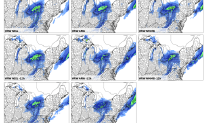
To show this in an easier to digest way check out the High Resolution Ensemble Forecast from midday Monday. All 4 of the current members showed less than 1" of snow in Connecticut (even eastern Connecticut) with the 4 older members showing an inch or two. There was a dramtic cut back from Sunday night to Monday midday.
In general, our high resolution models tends to resolve these "snow bands" well. While they struggle with the location they frequently sniff out their existence. In this case - nothing!
OK, So there's lift and not much dry air. How much snow will we get?
After getting questions 1 and 2 wrong with this storm (though they are related) the third one proved the most vexing. With a band of stronger lift with little dry air left the snow band went to town.
The strongest lift (upward vertical motion) was occuring at a temperature of about -15C. Believe it or not this is critical. This is the temperature at which snow flakes grow most efficiently (i.e. more bang for your buck with snowflake production) AND the favored snowflake is a dendrite. Dendrites are the beautiful ornate snowflakes that pile up very quickly and easily as they the branches of the crystals get tangled with one another.
Typically, 1" of liquid water yields about 10" of snow. Put another way if you take 10" of snow it would melt down to about 1" of water. Not this storm!
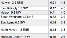
In Stonington 7" of snow fell this morning. That 7" of snow melted down to about 0.25" of liquid! That's a 28:1 snow to liquid ratio! Getting a ratio that high in southeastern Connecticut with 7" of snow is very, very, very unusual!
Lessons Learned
As much as a big forecast bust is personally disappointing to a meteorologist it's part of the job. Part of the excitement of weather to me is its unpredictability. More often than not the forecast is right but sometimes it's not - and sometimes like today it's wrong in a pretty spectacular fashion.
This turned out to be a perfect storm of errors. Getting one of the key points wrong resulted in a dramatically different result.
The nice thing about the weather is that there's always a new storm on the horizon. Let's hope the forecast is better!
