
Several inches of snow have fallen across the state and the number of power outages is expected to climb as winds gust over 50 mph.
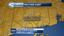
A high wind warning has been issued for all of Connecticut today.
The snow is winding down and will be done by 8 a.m.
Wind gusts will be strongest in higher terrain and in southeastern Connecticut.
Nine thousand outages are being reported as of 1:30 p.m.
High temperatures will be stuck in the 30s with wind chills in the teens.
Local

Tonight, temperatures fall back into the 20s in advance of another storm.
As a result, a freeze watch has been issued for southern Connecticut where the growing season has officially begun.
Snow will begin during the morning commute tomorrow and last through much of the daylight hours.
It's very difficult for snow to accumulate during the day in April, but with enough intensity, it can start to add up. This is especially true on unpaved surfaces.
While no accumulation is likely on the shoreline, a few inches are possible inland, with the bulls-eye being the higher elevations.
High temperatures will be near freezing inland but closer to 40 degrees along the shore, hence why no snow accumulation is expected by the water.
Roads will likely just be slushy much of the day across inland Connecticut.
Tuesday turns out dry with highs once again stuck in the 30s for most.
Mostly sunny skies stick around Wednesday, when high temperatures will be back in the 40s, finally.
Unsettled weather returns by Thursday, but by then, it will be rain and not snow with temperatures in the 50s.
