
After a gorgeous 2 days of weather we're going to see a dramatic change by tomorrow, Thursday and the weekend. The first item of interest in unseasonably cold weather for the next 48 hours.
Temperatures will be nearly 20 degrees colder than average with a dramatic shot of Arctic air. 850mb temperatures (about 5,000 feet above our heads) will be between 15c and 20c colder than average! That's a big negative anomaly. While there is a surge of more typical March air on the way for Friday and Saturday the weekend forecast remains intriguing.

A storm to our west will send moisture streaming into New England Sunday and Monday. This is a classic "overrunning" setup with warm air advecting north into New England BUT near the ground it's a much different story. The big key to the forecast is a large high pressure over northern Quebec that will nose south into New England. This will lead to a wedge of low level cold air with warmer air aloft and as a result the possibility for ice.
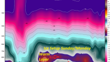
Let's take a look at the ECMWF (euro) and GFS temperature forecast. The Euro forecast shows a layer of mild air about 7 or 8,000 feet above us with colder air below it. This is an inversion. Snow will melt into rain drops in the warm layer and then either refreeze into an ice pellet or reach the ground as freezing rain. The GFS temperature forecast (shown here as a SKEW-T) shows a similar setup for later Sunday with an area of above freezing air above a shallow but notable subfreezing layer of air close to the ground.

At this point it's unlikely we'll get a major winter storm (i.e. excessive amounts of ice) but this is looking like it could be a nasty and unpleasant mix with some icy travel and chilly temperatures - especially for the time of year. Obviously lots can change over the next few days but this is something we're going to be watching closely.
