
March is supposed to go out like a lamb - not like this! On the 20th anniversary of the epic April Fools storm of 1997 it appears that parts of southern New England may see another winter storm.
Here in Connecticut the storm is going to be much too warm for all snow but a messy mix of snow, sleet, freezing rain and rain appears likely. The storm will be of a somewhat long duration with a period of some snow/mix as early as Friday morning with some mix continuing off and on through Friday night.
At this point, I'm not expecting a major event here in Connecticut. This time of year getting a major winter storm is tough to do - and with no cold high pressure anchored to the north this becomes all the more challenging to accomplish. A cold and raw mixture of rain, sleet, and snow seems more likely than a more significant wintry event.
That said, both our GFS and European models show the potential for some mixed precipitation and problems. The GFS model sounding valid prior to daybreak Friday shows a column cold enough for snow even in the valley around Hartford. If this were to verify we'd have to worry about the potential for a bit of slick travel in the morning prior to a change to rain.
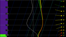
Another way of showing the temperature profile for this storm is to look at this time-height cross section from the European model at Bradley Airport which shows a classic signature for ice or sleet with warm air located above colder air near the surface. You can see this on the right side of the image below where temperatures 6,000 feet up reach 2C or 3C while temperatures near the ground are just below freezing.

At this point, I wouldn't expect a major winter event but some nuisance kinds of accumulation are possible - even in valley locations. Of course, it's possible this turns a bit colder and more wintry - especially in the hilltowns. One concern would be a stronger low pressure south of Connecticut Friday night with a period of heavier lift in the atmosphere in precipitation. This could promote a flip to heavy wet snow. Another possibility worth watching is an extended period of icing in the hills but given the time of year and lack of a good and cold high pressure to the north this seems unlikely to me right now.
Local

We'll be watching this closely over the coming days.
