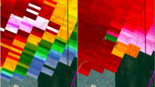
At 2:30 this afternoon I was preparing to do a severe weather cut-in for large hail in Northeastern Connecticut when a tornado warning was issued. The storm was rotating fast a little more than a mile above our heads but closer to the ground the rotation was fairly minimal.
The atmosphere supported rotating thunderstorms today. We were forecasting hail with a brief surge in elevated instability and strong wind shear. As a storm spins an enhanced "updraft" develops which helps hail stones grow larger and larger.

So why no tornado? The storm wasn't anchored near the ground. This storm was elevated - basically it was feeding off instability around a mile up. The atmosphere near the ground was very stable which would preclude tornado development - and also preclude strong winds from mixing to the ground. Hail, on the other hand, just has to rely on gravity. Gravity exists whether the air is stable or unstable so the hail stones fell to the ground readily and pelted Tolland, Stafford, and Willington.

