
A powerful spring storm will cut to the west of Connecticut bringing with it the potential for damaging southerly winds. At this point we are forecasting wind gusts of 55-65 mph across Connecticut with the potential for locally higher wind speeds in a few towns. The impact of this kind of wind is scattered tree and power line damage.
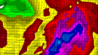
Our computer models are in great agreement that wind speeds of nearly 100 mph will be found only a few thousand feet above our heads Monday afternoon. In fact, the NAM computer model shows an area of winds approaching 120 mph in western Connecticut which is just about as strong as you'll ever see! We call this max in wind just off the ground the "low level jet" and it's present in just about all storms we see. The question now is how much of this low level jet will mix to the ground?
Not surprisingly wind approaching 120 mph at the ~5,000 foot level (technically, we are looking at the 850mb pressure level in the atmosphere) is extremely rare. In fact, a low level jet of this magnitude is approximately +6 standard deviations from normal! Imagine the extreme right tail end of a bell curve.
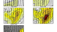
In order to diagnose how much of the wind will mix down we need to look at the vertical temperature structure of the lowest few thousand feet of the atmosphere. If the atmosphere is "well mixed" or unstable the wind we would assume about 80% of this momentum could mix down. Thankfully, it won't be. If we have a strong stable layer the atmosphere would mix down virtually none of the wind (i.e. 100 mph at 5,000 feet up and barely a puff of wind at the ground). We don't have that either.
What we do have is more of a "neutral" temperature profile which would promote some mixing. Probably something on the order of 40% of that low level jet. That's still a lot of wind! The big question here is how the low level temperature profile actually shakes out. The warmer we get on Monday the more momentum from aloft we'll mix down to the ground.
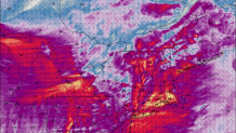
Our computer models try to make predictions based off the above and come up with a reasonable worst case scenario for gusts. This particular model (the HRRR) is quite close with a few of its counterparts and shows 60-75 mph gusts in many areas. Again, that would be a reasonable worst case scenario. 55-65 mph seems more reasonable for most area - with the potential for localized gusts around 70. If temperatures wind up a bit warmer - or if thunderstorms develop - a higher end wind event is possible with numerous/widespread outages versus scattered.
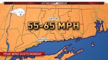
Bottom line is a significant wind event seems likely Monday. Widespread gusts of 55-65 mph Monday afternoon will lead to scattered to widespread tree and power issues. Thankfully, we are several weeks from full leaf-out which should mitigate tree damage some.
