
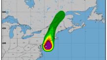
Rain and winds from Tropical Storm Fay were felt along the Connecticut shoreline starting Friday evening.
The National Weather Service has issued a tropical storm warning for coastal Connecticut and a flash flood watch for the entire state as Tropical Storm Fay brings periods of heavy rain and gusty wind along the shoreline.
While the heaviest of the rain looks to remain to our west, there is still a chance for locally heavy rain and flooding. All of Connecticut is under a Flash Flood Watch through 12 p.m. on Saturday.
The greatest concern with this storm is for flash flooding with an impressive amount of rainfall expected for a few towns, especially in western Connecticut.
There are also concerns for winds that could reach 40 miles per hour and take down a few trees or power lines. We also can't rule out the chance for an isolated small tornado, according to our First Alert Weather team, but the risk is very low.

Right now, it appears parts of the state could see 1-2" of rain.
The rain is expected to end early in the morning on Saturday with partial clearing in the afternoon. There is a chance for a scattered shower or storm Saturday evening. Saturday will remain extremely humid.


Sunday is expected to remain hot and humid with another round of scattered showers and thunderstorms in the afternoon.
Conditions are expected to improve next week, including declining humidity, starting on Monday.
Fay Local Watch/Warning Statement/Advisory Number 6
National Weather Service New York NY  AL062020
503 PM EDT Fri Jul 10 2020

CTZ010-110515-
/O.CON.KOKX.TR.W.1006.000000T0000Z-000000T0000Z/
Southern New Haven-
503 PM EDT Fri Jul 10 2020

...TROPICAL STORM WARNING REMAINS IN EFFECT...

* LOCATIONS AFFECTED
    - Milford
    - New Haven
    - Guilford

* WIND
    - LATEST LOCAL FORECAST: Equivalent Tropical Storm force wind
        - Peak Wind Forecast: 30-40 mph with gusts to 45 mph

    - THREAT TO LIFE AND PROPERTY THAT INCLUDES TYPICAL FORECAST
      UNCERTAINTY IN TRACK, SIZE AND INTENSITY: Potential for wind 39
      to 57 mph
        - The wind threat has remained nearly steady from the
          previous assessment.
        - PLAN: Plan for hazardous wind of equivalent tropical storm
          force.
        - PREPARE: Remaining efforts to protect property should be
          completed as soon as possible. Prepare for limited wind
          damage.
        - ACT: Move to safe shelter before the wind becomes hazardous.

    - POTENTIAL IMPACTS: Limited
        - Damage to porches, awnings, carports, sheds, and unanchored
          mobile homes. Unsecured lightweight objects blown about.
        - Many large tree limbs broken off. A few trees snapped or
          uprooted, but with greater numbers in places where trees
          are shallow rooted. Some fences and roadway signs blown
          over.
        - A few roads impassable from debris, particularly within
          urban or heavily wooded places. Hazardous driving
          conditions on bridges and other elevated roadways.
        - Scattered power and communications outages.

* STORM SURGE
    - No storm surge inundation forecast

    - THREAT TO LIFE AND PROPERTY THAT INCLUDES TYPICAL FORECAST
      UNCERTAINTY IN TRACK, SIZE AND INTENSITY: Little to no storm
      surge flooding
        - The storm surge threat has remained nearly steady from the
          previous assessment.
        - PLAN: There is little to no threat of storm surge flooding.
          Rough surf, coastal erosion, and life-threatening rip
          currents are possible.
        - PREPARE: Little to no preparations for storm surge flooding
          are needed.
        - ACT: Follow the instructions of local officials. Monitor
          forecasts.

    - POTENTIAL IMPACTS: Little to None
        - Little to no potential impacts from storm surge flooding.

* FLOODING RAIN
    - LATEST LOCAL FORECAST: Flash Flood Watch is in effect
        - Peak Rainfall Amounts: Additional around 1 inch

    - THREAT TO LIFE AND PROPERTY THAT INCLUDES TYPICAL FORECAST
      UNCERTAINTY IN TRACK, SIZE AND INTENSITY: Potential for
      moderate flooding rain
        - The flooding rain threat has remained nearly steady from
          the previous assessment.
        - PLAN: Emergency plans should include the potential for
          moderate flooding from heavy rain. Evacuations and rescues
          are possible.
        - PREPARE: Consider protective actions if you are in an area
          vulnerable to flooding.
        - ACT: Heed any flood watches and warnings. Failure to take
          action may result in serious injury or loss of life.

    - POTENTIAL IMPACTS: Significant
        - Moderate rainfall flooding may prompt several evacuations
          and rescues.
        - Rivers and streams may quickly become swollen with swifter
          currents and may overspill their banks in a few places,
          especially in usually vulnerable spots. Small streams,
          creeks and canals may overflow.
        - Flood waters can enter some structures or weaken
          foundations. Several places may experience expanded areas
          of rapid inundation at underpasses, low-lying spots, and
          poor drainage areas. Some streets and parking lots take on
          moving water as storm drains and retention ponds overflow.
          Driving conditions become hazardous. Some road and bridge
          closures.

* TORNADO
    - LATEST LOCAL FORECAST:
        - Situation is somewhat favorable for tornadoes

    - THREAT TO LIFE AND PROPERTY THAT INCLUDES TYPICAL FORECAST
      UNCERTAINTY IN TRACK, SIZE AND INTENSITY: Potential for a few
      tornadoes
        - The tornado threat has remained nearly steady from the
          previous assessment.
        - PLAN: Emergency plans should include the potential for a
          few tornadoes.
        - PREPARE: If your shelter is particularly vulnerable to
          tornadoes, prepare to relocate to safe shelter before
          hazardous weather arrives.
        - ACT: If a tornado warning is issued, be ready to shelter
          quickly.

    - POTENTIAL IMPACTS: Limited
        - The occurrence of isolated tornadoes can hinder the
          execution of emergency plans during tropical events.
        - A few places may experience tornado damage, along with
          power and communications disruptions.
        - Locations could realize roofs peeled off buildings,
          chimneys toppled, mobile homes pushed off foundations or
          overturned, large tree tops and branches snapped off,
          shallow-rooted trees knocked over, moving vehicles blown
          off roads, and small boats pulled from moorings.
Tropical Storm Fay Discussion Number   6
NWS National Hurricane Center Miami FL       AL062020
500 PM EDT Fri Jul 10 2020

Fay's structure is looking less tropical this afternoon. While the
central circulation is decidedly warm core, it is lacking deep
convection and consists entirely of low to mid-level clouds. The
deepest convection is found in cloud bands located well east and
southeast of the center. The initial intensity is set to 45 kt, with
the strongest winds found in a convective band northeast of the
center as seen in velocity data from the KOKX WSR-88D. The last fix
from the earlier aircraft mission provided a central pressure
estimate of 998 mb.

Gradual weakening should occur from here on as the cyclone begins to
interact more with land, however stronger winds are expected to
persist over water even after the center moves inland tonight. Fay
is shown as a 35-kt tropical storm inland at 12 hours, but those
winds are expected to be over water well southeast of the center by
that time. On Saturday, Fay should weaken as a post-tropical cyclone
and dissipate in 36 to 48 hours.

The initial motion estimate is 010/12 kt. The track forecast
reasoning remains unchanged, as Fay will be steered generally
northward and north-northeastward until dissipation between a
mid-level ridge over the western Atlantic and an approaching
shortwave trough moving across the Great Lakes. The new NHC track
forecast is close to the previous one and lies near the middle of
the guidance envelope.

Users should not place too much emphasis on the exact track of the
center of Fay, as heavy rainfall and strong winds will continue to
affect areas well away from the cyclone's center.

Key Messages:

1. Heavy rainfall from northern Delaware and eastern Pennsylvania
northeast across New Jersey, southeast New York, and portions of New
England may result in flash flooding and urban flooding in areas
with poor drainage.  While isolated minor flooding is possible,
widespread river flooding is not expected.

2. Tropical storm conditions will continue to spread northward
across portions of the mid-Atlantic and northeast coast today and
tonight, and a Tropical Storm Warning is in effect for the coasts
of New Jersey, New York, and Connecticut, including Long Island.
