
Here's a quick breakdown of what we're expecting from Thursday's snowstorm.
Snow begins: 1 a.m. - 4 a.m. Thursday
Peak of the snow: 8 a.m. - 2 p.m. Thursday
Snow Ends: Gradually during the evening
Peak Winds: Gusts to 50 mph Thursday afternoon and evening
In terms of accumulation we're going with a blend of the more amped up mesoscale computer models (like the NAM and RGEM) and the more subdued global models (like the GFS and ECMWF). In fact this blend results in a forecast that is pretty close to both the GFS and European ensembles.
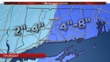
Could this change? Of course! This storm is extremely powerful and only a subtle wobble to the west would result in a much different kind of storm locally. This storm will feature powerful thunderstorms near its center and the pressure will drop to very low levels (likely between 950 and 960mb). We have seen some of our high resoltion guidance (guidance that can explicitly resolve thunderstorms) print out incredible snowfall back in Connecticut - some on the order of 1-2 feet. While these models can occasionally be right they also sometimes result in feedback loops that create incorrect (and overly extreme) solutions.
Local

Given the intensity of this storm it's worth watching closely. Small changes will make big differences in the outcome here in Connecticut.
