
Things are going to turn pretty ugly by tomorrow evening. A big nor'easter is going to cause all sorts of issues in Connecticut including damaging winds, heavy sleet, and coastal flooding.
The one change to the forecast is to delay the storm's arrival by several hours - it looks like substantial precipitation will hold off until the afternoon at the earliest. Winds should crank prior to the precipitation's arrival, however.
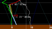
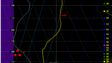
The storm is a big one and we're talking about some really impressive anomalies here. The U-wind anomalies are approaching -6 standard deviations which shows that this storm is quite powerful. Strong wind gusts are expected in areas where the atmosphere can remain mixed - that is most likely to happen in the hills and along the shoreline. This sounding off the NAM model shows the potential for 60 mph wind gusts in New Haven as early as mid afternoon Monday. Scattered power outages are expected in some areas.
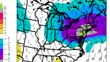
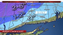
The second issue is going to be sleet - potentially a lot of sleet! There is going to be a warm pocket of air about 6,000 feet above our heads which should preclude snow in most locations. But as those snowflakes melt they'll run int a much colder pocket of air about 3,000 feet above our heads which should turn the melted snowflake over to an ice pellet. We are now expecting a relatively significant amount of sleet - 1" to 2" north and west of I-84 with up to an inch elsewhere (except the shore). Temperatures will remain at or above 32F in the valley and along the shoreline which should mitigate accumulation of sleet some.
In the Litchfield Hills temperatures will be even colder through the atmosphere and some mix with snow is expected as well. In these areas 2"-6" of mainly sleet and some snow is expected. This is going to be tough to shovel and an all around pain in the butt. The range is pretty large for now because I expect there will be large differences in snow and sleet accumulation over a short distance. The valley locations get the low amounts (i.e. downtown Torrington) while the hill tops get the higher amounts (i.e. Norfolk and Hartland).
Keep in mind that sleet accumulates at a much slower rate than snow. 1" of liquid precipitation yields about 10" of snow but only about 3" of sleet.
With this powerful storm we're also going to have to deal with excessive precipitation. Besides a wind-driven sleet we'll also see the precipitation mix with and change to rain in many locations. Some areas could see up the 3" of liquid precipitation by the time all is said and done with most areas around 1"-2".
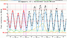
As for coastal flooding - we're in luck! Low astronomical tides plus the peak surge occuring at low tide should spare us from major issues. That said, with an easterly wind and big waves we should see at least some issues from splashover especially west of New Haven.
Here's the bottom line:
- Light precpitation Monday morning is not expected to cause any issues (temperatures will be above freezing so icing is not expected).
- Winds will pick up Monday afternoon with gusts to 50 mph possible around Hartford (there's a bit of uncertainty as to how high the winds will get in the valley as there could be a shallow stable layer that prevents the strong winds from mixing down) and wind gusts as high as 65 mph in southeastern Connecticut.
- Scattered power outages are likely Monday afternoon and Monday night.
- Heavier sleet (rain coast) moves in during the evening commute and could mix with or occasionally change to snow in the highest hill towns.
- A brutal evening of weather is expected with strong winds - especially at the coast - with a heavy, wind-driven sleet across the interior mixing with and changing to rain from time to time.
- 1"-2" of sleet is expected along and north of I-84 with 2"-6" of sleet and a bit of snow in the hilltowns of northwest Connecticut. Up to an inch of sleet is possible elsewhere in the state away from the immediate shore.
- The Tuesday morning commute will be OK in most locations with temperatures above freezing. Some lingering slushy patches from the sleet is possible in the hill towns.
