
It's not the earliest heat wave on record but it was pretty darn impressive. 94, 96, and 91 (at least) over the last 3 days makes this the first heat wave of 2017. The earliest heat wave on record occured back in 2002 when the mercury exceeded 90F for three consecutive days April 16-18.
With record warmth we managed a few loud storms last night. While the storms remained sub-severe with limited, if any, damage reports in the state they did wake many people up!
Many storms around here tend to weaken after the sun goes down. As the sun sets the atmosphere cools and instability wanes. Thunderstorms need an unstable atmosphere to form! Last night was different in that several clusters of storms actually strengthened around midnight. We actually expected this to happen as there were a few ingredients in place that were a bit unusual. The biggest was the unususally steep mid level lapse rates.
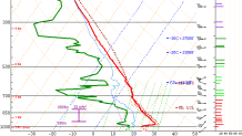
Lapse rates are easy to understand. It's simply the temperature difference between two levels of the atmosphere. We express lapse rates in degrees per kilometer - so the larger the value (or steeper the lapse rate) - the faster temperature decreases with height. This helps promote instability in the atmosphere. Last night the lapse rates were steep (in excess of 7C/km) and there was a surge in moisture a few thousand feet up after dark. The combination of increasing moisture underneath the steep mid level lapse rates helped fueld storms that lasted well into the night.
