
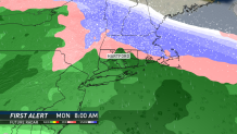
A Winter Storm Watch has been issued for most of northern Connecticut for Sunday night thru early Tuesday.
A Winter Storm Watch means that hazardous winter weather is possible in the watch area within 12-36 hours. This Winter Storm Watch has been issued for the potential of icing in the hills northwest and northeast of Hartford.
There isn't expected to be much, if any, snow with this system.
A storm will head to our west on Sunday night into Monday morning. Generally, a storm track to our west means we will see a warmer storm.
As this storm arrives, there will be an area of high pressure to the north, which may help to lock in enough cold air for a wintry mix for parts of the state.
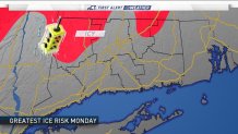
An extended period of icing across interior Connecticut is becoming more likely Monday morning. Farther north in central and northern New England significant snow is possible.
Local


While this storm is still a couple of days away, it will come during the busy travel days leading up to the New Year's holiday. Stay with NBC Connecticut as we get new information on the Sunday night storm.