
High pressure provided a quiet weekend with a blend of clouds and sunshine. By Monday, NBC Connecticut First Alert Meteorologists will be tracking a strong cold front moving through the state.
A strong area of low pressure will pass to our west on Monday. That will pull milder air into the state along with areas of rain, warmer temperatures and increasing wind.
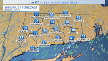
A round of rain will move through the state early in the morning. Much of the day will end up with a few showers, windy and mild. By evening, a strong cold front will bring an isolated thunderstorm, strong wind gusts (30-40+ mph gusts) and downpours.
Get Connecticut local news, weather forecasts and entertainment stories to your inbox. Sign up for NBC Connecticut newsletters.
Blustery and colder air will filter in behind the front for Tuesday. By Wednesday, another storm could bring wintry precipitation to the state. The storm could bring the first widespread accumulation to the state. The storm also could still pass to far south for less snow. Stay tuned!
We expect to know more about the Wednesday storm threat as more model data comes in over the next 24 hours.
