
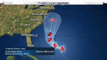
UPDATE: Jose strengthened into a Category 1 hurricane on Friday afternoon, according to the National Hurricane Center.
Connecticut in the possible path of Hurricane Jose. The NBC Connecticut meteorologists have issued a First Alert for Tuesday and Wednesday of next week.
Jose became a whole lot more interesting Thursday as our suite of computer models brought the storm much closer to Connecticut by Tuesday of next week.
The storm is moving west and by the weekend will begin a turn north along the east coast of the United States. What's unclear is how far west Jose will get and how strong Jose will be. The current forecast from the National Hurricane Center has Jose in a somewhat precarious position east of Norfolk, Virginia by 5 p.m. Tuesday.
Jose is essentially blocked from curving out into the Atlantic Ocean by a strong ridge of high pressure that stretches from Bermuda through the Canadian Maritimes. A blocking high to the east of New England is the single most important piece of the puzzle historically for landfalling northeast hurricanes.
The second piece of the puzzle is a trough of low pressure over the Great Lakes and Ohio River River Valley to "capture" the hurricane and pull it west while accelerating the storm north. We are missing this ingredient.

Only having one of the two ingredients likely rules out a landfalling hurricane in New England. The odds of this happening are extremely low. However, with the blocking ridge to the east Jose may be able to meander off the coast of the Mid Atlantic and bring us a period of wind and rain.
How close to Connecticut depends on how strong the west Atlantic ridge is (stronger would push Jose farther west) and how sharp the Great Lakes ridge is (oriented southwest to northeast would prevent Jose from getting too far north). With ridges all around Jose will be trapped for a period of time with nowhere to go and may slow to a crawl.
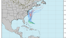
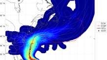
Where this crawl happens is uncertain. The GFS and Euro ensembles show significant spread but show about 25 percent of solutions close enough to southern New England for concern.
This setup reminds me a bit of Hurricane Edouard in 1996 that menaced New England Labor Day weekend. The storm slowly drifted north (blocked by a strong downstream ridge) and then scooted east at the last minute.

Without the capture and acceleration north (ingredient number 2 mentioned above) - Jose is likely to weaken gradually. A direct hurricane hit remains extremely unlikely and a moderate or strong tropical storm is a reasonable worst case scenario. Some wind and some rain.

How significant the storm is locally remains quite unclear but it's certainly worth watching.
