
A much colder air mass has settled into the state on this Easter Sunday.
Many towns will see highs only in the 40s to lower 50s. Winds will be between 10 and 20 mph creating wind chills, at times, in the 30s. A sprinkle or flurry is possible through the afternoon.
A freeze watch has been posted for the shoreline (where the growing season has begun) for Monday morning.
Get Connecticut local news, weather forecasts and entertainment stories to your inbox. Sign up for NBC Connecticut newsletters.
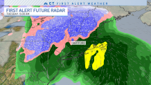
Beyond today's chill, attention turns to a coastal storm. The storm will move in Monday night into Tuesday morning. Heavy rain, wind and even some elevation snow is possible through Tuesday morning.
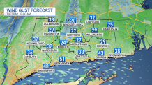
Wind could gust up to 40 mph in some locations.
Some snow accumulation is possible in the hills.
More detail on the upcoming coastal storm on our weather blog.
