
Saturday Weather Blog
Welcome to the weekend! A cold front moved through the state last night and with it more comfortable air is settling in for the weekend.
We can expect a good deal of sunshine both weekend days with comfortable air (dew point temps in the 40s and 50s) along with temperatures close to where they should be (around 80 degrees).

Get Connecticut local news, weather forecasts and entertainment stories to your inbox. Sign up for NBC Connecticut newsletters.
Sunday, Father's Day, will feature a bit more of a sea breeze at the coast. That will keep temperatures coolest along the coast (especially SE coast).

Enjoy this weekend's weather, because we have serious heat and humidity building in for next week.
It will be a very warm stretch of weather, something we have not seen so far this season - multiple days look to get into the 90s to near 100 degrees (and that's not even the feels like temperatures).

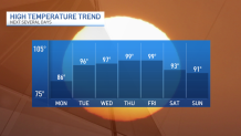
Some of these highs could even be record-breaking!

If you have to work or will be spending a lot of time outdoors next week be sure to drink plenty of water and take breaks indoor or a shaded area.
Local


Tracking The Tropics
June 1 marked the start of the 2024 hurricane season. Here is the list of names for the season ahead.

A widespread area of Saharan Dust is helping to keep the eastern Atlantic quiet . . . for now. Even though water temperatures are very warm for this time of year (a big factor that works in favor of storm development), large amounts of dust work against tropical development.
The heavy rain impacting South Florida looks to move out over the next couple of days. Another area The National Hurricane Center has been keeping an eye on will be in the western Gulf of Mexico. There is a 50% chance that something tropical will develop over the next 5-7 days. In fact, there are signals of a serious flood threat in portions of Central America over the next several days. Some of that moisture will be drawn in to Texas.

