
What to Know
- Snow will develop statewide on Saturday night and transition to a wintry mix overnight.
- The majority of the state can expect 3 - 6 inches, and 2"-4" along the southeastern shore.
- After the storm, it will be brutally cold with temperatures of 0 to 10 degrees and wind chills down to -20 Monday morning.
The NBC Connecticut meteorologists continue to track a nasty storm that is moving in tonight and could make a mess of the second half of the weekend.
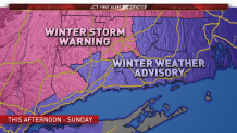
A Winter Storm Warning is in effect for Litchfield, Hartford and Northern Fairfield counties. A Winter Weather Advisory remains in effect for the rest of the state.
Snow is moving in now and turns to a mix of sleet and freezing rain overnight and Sunday morning. The mix tapers off mid to late morning Sunday. A quicker change to rain for the southern half of the state is likely as warmer air moves in.
There is some indication that the majority of the storm will stay wintry for the northern third of Connecticut, especially into the hill towns, with a freezing rain accreting on tree limbs and power lines. Scattered power outages are possible.
Roads will likely be messy, but with the majority of the storm will be during the overnight hours and pre-dawn Sunday.
Amtrak has announced service changes due to the storm.
Right now it appears we could be dealing with measurable snow for interior Connecticut and especially the northwest hills with much of the snow before switching over to prolonged icing.
While the snow may not be terribly deep, the sleet and freezing rain will make it dense and heavy to shovel. Most of what falls along the shoreline will wash away once we switch over to rain.
Local


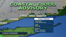
Coastal flooding: A coastal flood advisory has been posted for the shoreline during the time of high tide on Sunday morning. There is also a Flash Flood Watch for the immediate shoreline. Minor to moderate coastal flooding is possible during the time of high tide (8-10 AM Sunday).
After the storm pulls away Sunday afternoon a cold blast of air will arrive and some very cold temperatures are expected Monday morning. This will cause a flash freeze and any untreated surfaces will become very icy and we expect slick travel Monday morning with temperatures of 0 to 10 degrees and a wind chill factor making it feel -10 to -15.
The governor plans to activate the state's Severe Cold Weather Protocol starting Sunday at noon for those in need of shelter.
