Over the last couple years we've had a few unusual late season snow and ice events. Last April we managed an extremely rare springtime freezing rain event that produced 0.20" of ice accretion in New Haven during the day on the second coldest April day on record! 3 years ago I had a spectacular forecast bust with a burst of heavy snow that suddenly occured during the morning commute dropping 5" of snow in only about 2 hours on parts of the I-91 corridor on March 31, 2014.
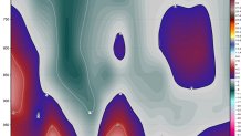
With those two storms in mind - what kind of surprise does Friday's storm have in store for us? We know we're going to see a good burst of precipitation - particularly Friday evening and Friday night - with over 1" of liquid falling. Good for the drought! The temperature profile is what makes this storm so tricky. As I wrote about yesterday there's not a good cold high pressure anchored to the north so getting excessive snowfall is going to be tough. Take a look at this time-height cross section of temperature for Bradley Airport off the European model. You can see a pocket of warmer air a few thousand feet above the ground with colder air below it. This would favor sleet and freezing rain.

The GFS model is colder than the Euro and a blend of the two would yield a period of snow, sleet, and even some freezing rain across areas north of I-84. We will have to monitor this closely as a degree in either direction would mean a drastic change in the forecast. Here's what I'm thinking right now:
- Light mixture of snow, sleet, and rain during the day Friday. While a few slick spots are possible Friday morning if snow develops around daybreak most of the day should be problem-free on the roads. Light snow and sleet rates and the strong sun angle should do the job to keep roads wet.
- Heavier precipitation will develop Friday evening and Friday night.
- Mainly rain is expected along the shoreline Friday evening/night with occasional sleet pellets.
- Inland areas will see a mixture of sleet and rain along I-84 in the higher elevations and in the hills sleet and freezing rain may be the dominant precipitation type. Some snow is possible as well near the Massachusetts border with several inches of accumulation possible.
- The storm will peak during the overnight hours with everyhing winding down shortly after daybreak Saturday.
- While there is likely to be an icy mix and slushy accumulation north and west of I-84 (especially in the hills) there are two less likely things we'll have to watch foe. One is the potential for a colder solution which would mean more snow - including in the valley north of Hartford. The second thing to watch for is the potential for an extended period of freezing rain in the hill towns which would weigh on trees and powerlines.

