
The modern tornado record goes back to 1950. Until Saturday, a tornado had never been recorded in Connecticut during the months of November or December.
Saturday's severe weather event featured a powerful line of thunderstorms that produced small hail and strong winds. This line also produced four tornadoes in Connecticut and several more on Long Island.
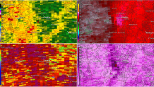
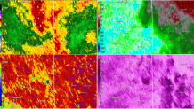
Advances in radar technology allow us to not only see the wind speed and direction in a storm (which is useful for picking out areas of rotation) but also whether the radar is picking up rain drops or other targets.
Get Connecticut local news, weather forecasts and entertainment stories to your inbox. Sign up for NBC Connecticut newsletters.
In Saturday's case, there were three instances of lofted tornado debris in Connecticut known as a Tornado Debris Signature or TDS, which we were able to detect in real time.
The first TDS occurred in Cheshire at 3:31 p.m. just west of downtown. There is a fairly widespread area of damage in this part of town.
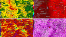
At 3:45 p.m., the southern portion of the line that had been exhibiting rotation over Long Island Sound moved inland over Branford and resulted in a tornado touch down in the Pine Orchard section of town. Lofted tornado debris was detected into portions of Guilford with sporadic damage reports as far northeast at Cornwall Road in the Guilford Lakes section of town.
A third tornado touched down in northeastern Connecticut. It started in Griswold and continued into Plainfield, Sterling, and Rhode Island. The Tornado Debris Signature was quite clear from the weather radar in Boston and there are several reports of damage.
A tornado hit the Pawcatuck section of Stonington and adjacent sections of Westerly, RI. It featured wind gusts of up to 90 mph.
Local
The National Weather Service confirmed that four tornadoes, ranging from EF-0 to EF-1, did in fact touchdown in Connecticut.
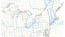
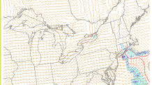
Saturday's tornado event was well forecast. On Friday, we mentioned severe weather was possible and by Saturday morning, our forecast was more certain and included the risk for tornadoes given the strong low level wind shear and an adequate amount of instability.
This was certainly a November severe weather event to remember. Thankfully, there are no reports of injuries and few reports of structural damage.
