A wintry mix is expected to move in Friday, and hundreds of schools and organizations have decided to close. See the list here.
The NBC Connecticut First Alert weather team has issued a First Alert for the anticipated snow and sleet. The morning drive looks quite slippery and messy.
This comes after temperatures reached the high-60s and low-70s Wednesday, hitting or breaking records.
329 medal events. 32 sports. Endless drama. Catch all the action at the Paris Olympics. Sign up for our free Olympics Headlines newsletter.
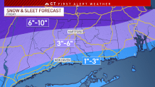
Winter storm warnings have been issued for Windham, Hartford and Tolland counties. A winter storm watch has been issued for Litchfield County.
Winter weather advisories have been issued for Fairfield, New Haven, New London and Middlesex counties.
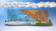
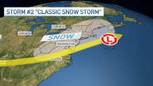
Low pressure will ride along a front Thursday night into the day on Friday. This provides the energy and moisture (while locking in the cold air from the north thanks to counter-clockwise airflow) for us to see snow.
Computer models agree that we start as snow and then change over to a wintry mix. We could transition from a mix back to snow before the system pulls far enough away later on Friday.

State Office Buildings Closed
Local


Gov. Ned Lamont announced that all executive branch state office buildings will be closed to the public Friday because of the snowstorm.
Any level 2, or nonessential, employees who can telework are being asked to do so. Any other level 2 employees who can't do their jobs from home shouldn't report to work in-person.
“Because this snowstorm is expected to have a significant impact on the morning commute, and out of an abundance of caution, we are closing state office buildings for the day on Friday,” Lamont said. "I strongly encourage everyone in Connecticut to stay off the roads on Friday morning unless absolutely necessary, particularly during the height of the storm so that DOT crews can clear the roads and keep everyone safe.”
The chance for accumulating snow has been pretty consistent since the weekend. The highest snow totals look like they'll set up in northern Connecticut. With the changeover to wintry mix, sleet may mix in with snow, making it tough to shovel.
Snow will develop prior to daybreak with the heaviest snow falling between 4 a.m. and 10 a.m. As warm air moves in at cloud level the snow will change to sleet from south to north. Where there is more sleet, accumulations will be a bit lower but farther north there will be less sleet and higher snow accumulation.
Everyone across the state will see wintry weather through much of the day on Friday, however - including the morning AND evening commutes. It looks like the morning commute will be hit harder than the evening. Travel through the day will be tricky.
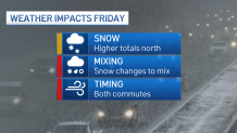
The storm will wind down by midday with occasional light wintry mix falling during the afternoon.