NBC Connecticut First Alert meteorologists have issued a First Alert for a wintry mix Thursday night into Friday and snow and ice are possible on Friday.
The First Alert includes all of Connecticut.
A storm system will bring light to moderate rain to the state tonight. There will be periods of on and off rain.
Get Connecticut local news, weather forecasts and entertainment stories to your inbox. Sign up for NBC Connecticut newsletters.
As the storm system moves through the region, a cold front will move down from the north. This will cause the rain to transition to a wintry mix of freezing rain, sleet, and snow as we head into Friday morning and afternoon.
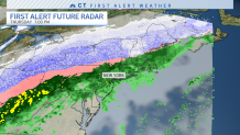
Temperatures will drop below freezing during the day Friday and the rain will change to ice and snow.
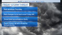
Some accumulating snow is expected. Our meteorologists are continuing to track how much snow we may see.
Slippery roads are also a concern.
The snow will taper off by sunset on Friday.