
A line of thunderstorms produced heavy rain through parts of Litchfield County Sunday afternoon.
Radar estimates of up to and over 6 inches of rain within six hours around route 272 around Norfolk.
Get Connecticut local news, weather forecasts and entertainment stories to your inbox. Sign up for NBC Connecticut newsletters.
The National Weather Service said 2 to 3 inches of rain has already fallen in the area and another 1 to 2 inches is expected.
A flash flood watch is issued for all of Connecticut through Tuesday morning.

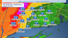
There is the potential for several rounds of showers and storms beginning this afternoon and lasting through Monday. Some towns in western Connecticut could pick up several inches of rain.
Local


Most of the heavy downpours are likely going to be focused in western Connecticut. The axis of heavy rain will shift from west to east overnight tonight through Monday.
Severe weather can't be ruled out on Monday as well. Localized strong wind gusts are possible. The Severe Storms Prediction Center (SPC) has placed the entire state in a level 1 (out of 5) risk for severe weather on Monday.

Track the storms and read more about the flood threat on our weather blog.
