
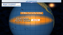
NOAA says the current El Niño pattern has reached the threshold to be called “strong."
Let's take a look at what that meant for past El Niño winters in Connecticut.
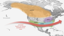
First, El Niño is the warmer phase of what’s called ENSO, short for El Niño Southern Oscillation, where we look at the water temps of the equatorial pacific and how that impacts weather patterns. El Niño happens when the water temperatures in that region are above normal.
Get Connecticut local news, weather forecasts and entertainment stories to your inbox. Sign up for NBC Connecticut newsletters.
La Niña represents the phase where the water temperatures are cooler than normal and ENSO neutral occurs when the waters are neither warmer nor cooler than normal.
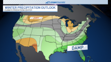
The current NOAA meteorological winter outlook (described as Dec. 1 to Feb. 29) is for overall above average temperatures and near-average precipitation, with a slight chance of being above average.
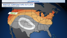
To clarify, that could mean one really snowy or really cold month, and then the rest of the season turns the tide in the other direction.
Local


The outlook doesn't tell us exactly how above or below a specific month or week may be, but looks at the three-month period as a whole. Keep that in mind when looking at these outlooks.
Let’s look back: the last El Niño winter we had was 2018-19.
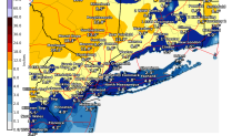
The first thing you may think is “January 2019 ice storm” – but also 6" of snow fell in Canaan, just under 5" in Litchfield and 3" in Roxbury.
A little earlier in the season, the mid-November storm struck before Thanksgiving where 8" fell in Bethel, just over 8" in Newtown, and up to a foot was reported around New Fairfield.
The previous El Niño year to that was 2015-16 when Bridgeport recorded its coldest February temperature at -6°F (six degrees below zero) on Valentines day.
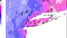
Over a half foot of snow fell during an early February storm in areas like Norwalk, Easton and West Haven.
11" of snow was reported in Killingly just a couple of days later.
The second storm also produced around 5" in Columbia, Southington and Burlington.
That winter still stands as warmest on record in the Hartford area, which includes, New Britain, Avon and Bloomfield.
2014-15 was the only other El Niño winter within the last decade – a doozy of a winter where storm totals were measured in feet.
Folks around Weston probably still think about the storm that left them with over 14" of new snow.
Totals like 17" in Guilford, around 20" in Essex and Deep River, and about 2 feet (24") around Preston, Bozrah and Sprague tell the story of that winter.
So while the warm-leaning outlook may seem grim for snow lovers, that doesn’t mean we won’t get snow at all – even blizzards are possible during El Niño winters.
Stick with your NBC Connecticut StormTracker weather team for what this winter will bring.
Be prepared for your day and week ahead. Sign up for our weather newsletter.
