
NBC Connecticut meteorologists have issued a First Alert for extreme heat expected Sunday and an Excessive Heat Warning has been issued for all of the state.
The heat that began on Friday with highs in the middle 90s will continue through today.
Temperatures on Saturday reached the upper 90s. The extreme heat continued Sunday - hitting 100 at Bradley International airport for the first time since 2012.
The bigger concern will be heat index value of 105 to 110. The heat index is calcuated by combining the temperature and dew point values. Dew point values will be in the mid 70s across the state this weekend, making it feel oppressive and very humid outside.
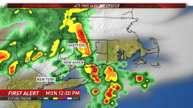
Showers and storms will move into the state for Monday and Tuesday associated with a cold front. The front will bring an end to the extreme heat and bring lower humidity by Tuesday.
The state Department of Energy and Environmental Protection is warning that, in addition to the heat, they are expecting unhealthy levels of ozone across the state through Sunday.
Local


“Along with high temperatures, unfortunately, we expect to see high levels of air pollution and it is important to take appropriate precautions when ozone levels are elevated during a major heat wave,” DEEP Commissioner Katie Dykes said in a statement. “Residents planning to spend time outdoors this weekend working or exercising should be mindful of air quality and consider limiting strenuous outdoor activity.”
The rest of the week will feature warm temperatures in the middle to upper 80s along with moderate levels of humidity.
