
Snow will continue moving through the state this evening. The heaviest snow will happen through midnight.
We also have dozens of closings due to the storm. You can see the full list here.
Most of the state is expected to get between 5 and 10 inches of snow. In some parts of northern Connecticut, there could be as much as a foot of snow.
Get Connecticut local news, weather forecasts and entertainment stories to your inbox. Sign up for NBC Connecticut newsletters.

As you go south in the state, there will be less snow with less than two inches expected along the immediate shoreline in New London County. Two to five inches of snow is expected for New Haven.
There were cloudy and dry conditions Saturday afternoon with temperatures in the mid 30s. The snow began to move into the state in the late afternoon.
Local

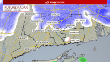
Around dinner time, the snow pushed eastward and overspread the state. The snow started coming down heavier around 9 p.m. Snowfall rates between 1" to 2" per hour will be possible, coating the roads quickly.
Here's an hour-by-hour look at what you can expect from the nor'easter:

The heavy snow will continue through about midnight.
During the overnight hours, the snow will come down lighter and more intermittently, and mixed precipitation will likely occur for the shoreline.
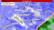
Wrap-around snow showers will fill into the state around midday on Sunday. An additional inch or two of accumulation is possible.
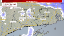
By Sunday afternoon, the snow will be much more scattered as it moves out of the state.
You can get the latest details on the storm here.
Be prepared for your day and week ahead. Sign up for our weather newsletter.
