
Connecticut meteorologists love talking about nor’easters but do you know about the state’s biggest southeaster? The “Great Appalachian Storm” of November 25, 1950 was one of Connecticut’s most violent wind storms on record. In some towns the wind speeds in 1950 were only exceeded by the great hurricane of 1938!

The storm was only of modest strength in terms of central pressure – 980ish mb. But what made the winds vicious was the 1050ish mb high near Maine. The freakishly strong pressure gradient produced violent southeasterly and easterly winds across New England. Here are some of the wind gusts recorded in Connecticut on November 25, 1950.
- Bridgeport – 88 m.p.h.
- New Haven – 77 m.p.h.
- Hartford – 100 m.p.h.
The 70 m.p.h. "fastest mile" wind in Hartford remains the strongest wind recorded for the official Hartford records since observations began in 1904. The second highest value is 64 m.p.h. recorded during the October 3, 1979 tornado. In Bridgeport the sustained wind of 62 m.p.h. is one of the highest on record (since 1948) with the highest occurring during Gloria in 1985 at 74 m.p.h. sustained and two other higher wind speeds during the winters of 1964 and 1969. Note on record: 2-minute sustained winds replaced 1-minute sustained winds in 1995 and this record is "fastest mile" which is different anyway.

For a non-tropical storm there’s no question in my mind that the 1950 southeaster was the most violent windstorm we’ve seen. The standardized anomalies from Richard Grumm at the NWS in State College shows a wide area of +4 standard deviation 850mb winds. That’s quite a low level jet! The winds reached 160 m.p.h. on Mount Washington in the core of that LLJ.

Looking at the reports from that day here in Connecticut temperatures in the warm sector came close to 60º with highs in the upper 50s in Hartford, Bridgeport, and New Haven. The unseasonably warm weather, when coupled with a a ripping low level jet, lead to enough turbulent mixing to mix down destructive winds – in some cases to 100 m.p.h.!
Local


Here are some of the comments from the official weather bureau reports.
Hartford – “Of paramount interest in this month’s weather is the occurrence of “The Great Wind Storm of November 25, 1950″. Considering its great extent, extreme weather of various types, and its unusual meteorological character, this storm will be long remembered. At Hartford, E’ly winds averaged the amazing speed of 38 m.p.h. for the entire day of the 25th, and attained gust speeds of at least 100 m.p.h. on at least 3 occasions between 4:30 and 7:30 p.m..”
Bridgeport -” Storm of Nov. 25th worst since 1938. Station inundated with 4 to 5 feet of water.”
New Haven – “Severe southeast storm on 25th. Extensive wind and water damage to shore fronts. Many trees, wires, antennae down, roofs damaged. Max for 5 minutes: 50 SE at 1:55 PM (17 Hrs.), probably exceeded 8:00-9:00 PM. Fastest single mile: 57 SE at 1:56 PM (17 Hrs.), possible exceeded 8:00-9:00 PM. Gusts: 55 MPH at 1:35 PM; 66 MPH at 4:20 PM; 66 MPH at 7:40 PM; 77 MPH 5 second gust at 4:45 PM… 5 min. max record; fastest mile exceded in Sept. 1903.”
The strong winds produced widespread tree and power line damage across the state. The winds tore a roof off a dormitory at UConn and ripped shingles off roofs across the state. Several shoreline homes lost their roofs according to a Hartford Courant article from shortly after the storm.
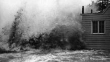
The storm surge flooding was extensive on the coast. In New London the tide reached an impressive 7.58ft MLLW. The only storms higher in the last 100 years are the 1938 hurricane, hurricane Carol, and hurricane Sandy. In Stamford at the Hurricane Barrier the tide reached 9.5ft NGVD which was similar to Irene’s tide level.
Much like Sandy, the storm surge flooded large portions of New York City including the lower east side and Laguardia Airport. Sandy’s surge, however, was much more powerful in the parts of the City, like Staten Island and the Rockaways, with Atlantic exposure.
On the Connecticut shoreline houses, cottages, railroad tracks, and beaches were swept away. Newspaper accounts indicate that the sand was several feet deep on coastal roads and was removed by snow plows. Many people had to be rescued from their homes after refusing to heed evacuation orders.
This type of unusually deep system lead to unusually cold weather and extreme snowfall in the Appalachians and the Ohio River valley. The storm is one of the worst blizzards in parts of the country. Steubenville, Ohio recorded 44 inches of snow while the synoptic desert of Pittsburgh dug out from 30.5 inches of snow!

In the southeast U.S. the backside of the storm delivered a bitterly cold air mass. The mercury dropped to -3º in Atlanta, GA. Many observing sites saw their coldest November temperatures on record. 850mb temperatures reached an INCREDIBLE -20ºC over northern Georgia at 12z 11/25/1950.
Not very often do you see a -6 sigma 850mb temperature! The exceptional baroclinicity and phasing resulted in what amounted to one of the most impressive east coast storms of the 20th century.
While we frequently refer to the March 1993 storm as the “storm of the century” the November 1950 storm gives ’93 a run for its money. For east coast storms we really had 2 storms of the 20th century.
