
Tuesday Weather Blog
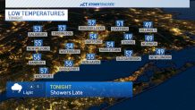
It was a taste of summer on Tuesday across Connecticut with high temperatures in the low 80s and upper 70s.
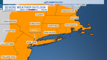
The big weather story for the next couple of days is the severe weather threat in the plains states. The Storm Prediction Center issued a RARE level 5 High risk for severe storms Monday, and now a severe weather threat is moving east.
Get Connecticut local news, weather forecasts and entertainment stories to your inbox. Sign up for NBC Connecticut newsletters.
By Wednesday the highest risk of severe weather includes Memphis to St. Louis and near Cincinnati. A lower, level 1 risk for severe weather has been placed over all of CT, meaning that an isolated storm could become stronger.
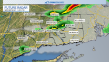
Scattered storms will move in Wednesday morning, some of which could be briefly on the stronger side. Fortunately, it will be nothing like what the Plains states have been going through.

Unfortunately, Wednesday is just the first round of rain for us. We'll be keeping an eye on several waves of energy that are expected to move through CT. Most of Thursday is looking dry with scattered showers moving in later in the afternoon and evening. Temps will be cooler in the mid-60s.
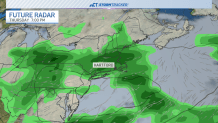
Scattered showers could linger through Friday with drier conditions for Saturday with highs falling into the lower 60s.
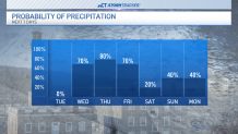
Temperatures look to rebound back to the upper 60s on Mother's Day Sunday with scattered rain chances.
