Severe thunderstorm watches across the state were canceled Wednesday afternoon, though some less powerful storms will still move through some areas.
A severe thunderstorm warning was issued for New Haven and Middlesex counties but has since expired.
A storm moved through Hamden and into Wallingford around 2 p.m. before moving towards Middletown and weakening.
Severe thunderstorm watches have been issued for Fairfield, New Haven, Middlesex, and New London counties until 8 p.m. Watches for Hartford, Tolland, and Windham counties have been canceled.
Get Connecticut local news, weather forecasts and entertainment stories to your inbox. Sign up for NBC Connecticut newsletters.
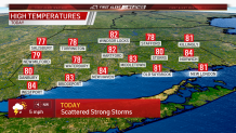
Today will feature partly sunny skies and will be warm and humid. Highs will be in the 80s.
More storms could develop throughout the afternoon and evening. The storms could produce gusty wind and small hail.
The storms have the best chance of being severe from 1 p.m. to 6 p.m.
By tomorrow, much drier air develops. It will be partly sunny and highs will be in the 80s.
Friday looks mostly sunny with highs in the upper 70s.