Power companies are dealing with outages as strong winds gust on Monday.
The highest wind gust as of around 2 p.m. was 55 miles per hour at Bradley Airport.
Power was out for more than 11,000 Eversource customers on Monday afternoon, down from 15,000 at one point, and around 650 United Illuminating customers, down from more than 2,000.
Indian Well State Park in Shelton is closed due to storm damage.
Several road closures are reported in New Canaan.
- North Wilton Road @ Bald Hill Road
- 201 Colonial Hill Road
- 166 Cross Ridge Road
- 170 Weed Street
- 56 Willowbrook
- 56 Pequot Lane
- 398 Valley Road
- 65 Mill Road
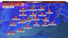
The wind chill value combined with the wind will make it feel like 20 to 30 degrees today.
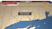
A wind advisory is in effect for all of Connecticut Monday from 9 a.m. to 6 p.m. Winds will be out of the west sustained at 20 to 30 mph with gusts between 40 and 50 mph. Occasional gusts to 55 mph are possible.
In Simsbury, a tree came down on Nod Road at the Route 185 intersection.
Earlier Monday, snow was coming down in Litchfield and New Haven counties and into the Naugatuck Valley.
This is being aided by Lake Ontario.
As winds increase, the threat for scattered power outages will also increase with peak wind gusts expected Monday morning into the afternoon.
Local


In addition to the strong wind, cold temperatures will be present on Monday. High temperatures for inland Connecticut are expected to remain in the upper 30s for much of the day.
When you combine the strong wind with below normal temperatures, wind chill values will range from 20 to 30 degrees during the afternoon.