
There are only a few “classic” northeastern U.S. tornado outbreaks that jump out in your mind. The 1985 Pennsylvania outbreak is one, the 1998 Pennsylvania/New York outbreak is another, and so is the 1989 northeast outbreak. The epicenter of that outbreak was right here in Connecticut with an F4 tornado touchdown in Hamden and New Haven.
The atmosphere couldn’t have been more primed for a big tornado event. Here’s the morning weather balloon launch and sounding from Albany.
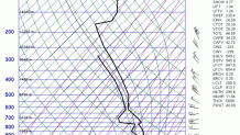
A classic elevated mixed layer with a dry adiabatic layer from 625mb through 750mb is present. What is most striking, however, is the exceptional wind shear in the atmosphere. Winds at 500mb are out of the northwest at 80 knots while in the boundary layer winds are out of the south-southeast at 10 knots! That’s about as strong as it gets.
The presence of the “EML” allowed for significant instability to develop during the heating of the day. Prior to the tornado in Connecticut temperatures reached the low and middle 80s with dew points in excess of 70F. A quick and dirty modification of that sounding for 30/22 shows just how explosively unstable the atmosphere was.
The first tornado touched down in upstate New York west of Albany and was on the ground for an incredible 42 miles. That same supercell went on to produce a series of tornadoes in Connecticut. The first tornado touched down near Route 4 in Cornwall and continued south into Bantam. The second tornado touched down in Watertown and Waterbury. The most violent of the tornadoes touched down in Hamden and continued south into New Haven.
The weather charts during the event were just incredible for a northeastern U.S. tornado outbreak with a strong disturbance moving out of southern Quebec into northern New England.
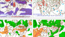
Through the day 500mb heights actually rise over southern New England with the best QG forcing displaced far to the north. Still, after the initial convective initiation in the morning those storms were able to propagate southeast into our area. The elevated mixed layer not only allowed strong instability to develop – it likely also helped keep convection relatively discrete. The atmosphere in many locations was “capped” – just enough CIN to prevent widespread convective initiation – but not capped enough to prevent all convection. The best QG forcing to the north also helped convection remain relatively scattered.
Local

The damage in Connecticut was substantial with hundreds and hundreds of homes and businesses destroyed. Many people in the New Haven suburbs – including North Haven and North Branford were caught in the hail core of the storm with golf ball size hail or larger. Southeast of where the tornado lifted in Newhallville substantial wind damage occurred with many of the pine trees near Lake Saltonstall on the Branford/East Haven line snapped in half.
Here is some of our coverage from the 6 p.m. news on July 11, 1989.
There were other tornadoes that day – some in northern Massachusetts, others just west of Danbury in Putnam County, and another swarm in northern New Jersey. If we were able to look at radar data (which sadly, we cannot) we’d probably see a line of supercells across the region.
On a personal note, the 1989 tornado event is my first weather memory as a kid. At the time I was living in Branford but on vacation with my family on Cape Cod. When I heard about the tornado back home I was devastated! I couldn’t believe that I missed “the big one” back home. I guess I’ve been a weather weenie for 25 full years now!
