
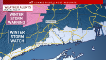
Our meteorologists are tracking a major nor'easter that could bring over a foot of snow to parts of the state early this week.
The storm will form Monday into Tuesday. Rain will begin across most of Connecticut and will quickly change to snow in the Northwest Hills.
Around Hartford and through most of the I-84 corridor, rain will begin changing to snow prior to daybreak on Tuesday.
Get Connecticut local news, weather forecasts and entertainment stories to your inbox. Sign up for NBC Connecticut newsletters.
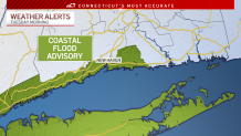
Along the shoreline, the rain may never completely change to snow. A Coastal Flood Advisory has been issued for parts of southern Fairfield and New Haven counties.
Temperatures will be close to freezing so any snow is expected to be heavy and wet. Power outages are possible.
Local

Eversource is preparing crews and is getting equipment ready ahead of the storm. Additional out-of-state crews are also being brought in to help with restoring power to customers, if needed.
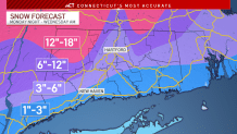
There will be a variation of snow totals across the state with elevation playing a role. Communities along the shoreline could see 1 to 3 inches (or less - temperatures may be too mild for snow) while some people in northwest Connecticut could see as much as 18 inches.
Since the storm is still a few days out, it's possible the storm's track and intensity could change.
The rain and snow will taper off Tuesday afternoon and evening statewide.
You can get the latest details anytime here.
Be prepared for your day and week ahead. Sign up for our weather newsletter.
